
Abstract
The importance of horticulture around the large cities, called green belt (GB), or proximity food production area is related to its contribution to the provision of food as well as its role on social, cultural and ecological aspects. Geoscience and Remote sensing (GRS) are tools that should aid in gathering and updating the information to develop science-based management plans of this areas. Recently, the improvement in terms of spatial, temporal and radiometric resolutions has changed the performance and the approach to the horticulture remote sensing. In this work, we make a brief review on the literature exploring the use of GRS techniques in horticulture, and future trends in order to exploit the available techniques for efficient crop management in the way to improve territorial planning and management. Specifically we found a lack of academic production in this area. In addition we examine the importance of this landscape areas from different points of view (food security, health, ecology, etc.). A systematic revision of published studies on remote sensing on horticulture including different platforms, sensors and methodologies are briefly presented. Finally some aspect related with future trends are discussed.
Author Contributions
Academic Editor: Abubaker Haroun Mohamed Adam, Department of Crop Science (Agronomy), College of Agriculture, Bahri University- Alkadaru- Khartoum -Sudan.
Checked for plagiarism: Yes
Review by: Single-blind
Copyright © 2019 M. Victoria Marinelli, et al.
 This is an open-access article distributed under the terms of the Creative Commons Attribution License, which permits unrestricted use, distribution, and reproduction in any medium, provided the original author and source are credited.
Competing interests
The authors have declared that no competing interests exist.
Citation:
Introduction
Horticulture is work culture, science, technology and business involved in the production of vegetables for consumption. Horticulture generally is thought as the technique of growing plants that are developed in orchards. The term comes etymologically from the Latin words hotus (’garden’, ’orchard’, ’plant’) and culture (’cultivation’), i.e. ’cultivation in orchards’.
According to the International Society of Horticultural Sciences (ISHS), horticulture includes floriculture (production of cut flowers and ornamentals), olericulture, fruit growing, and the cultivation of aromatic or medicinal species.
Horticulture crops play significant role in improving the productivity of land, generating employment, enhancing exports, improving economic conditions of the farmers and entrepreneurs and providing food and nutritional security to the people 1. Especially, the horticulture around the cities are called green belt (GB) and nowadays are identified as a modern urban planning tool that contributes to local food security, protects ecological integrity, conserves biodiversity, cares for local water quantity and quality, and provides recreational areas and constitutes a brake on urban expansion 2, 3. In particular, for better management of the existing crops and to bring more area under horticulture crops, updated and accurate database is necessary for systematic planning and decision making.
Remote sensing and geomatic science (GRS) are advanced tools that aids in gathering and updating information to develop scientific management plans. Many types of sensors namely microwave radiometers, laser meters, magnetic sensors and cameras collect electromagnetic information to derive accurate, large-scale information about the Earth’s surface and atmosphere. Recently, the improvement in terms of spatial, temporal and radiometric resolutions; and the accessibility of airborne sensors or unmanned aerial vehicle (UAV) has change the performance and the approach to the horticulture remote sensing. Because these data and images are digital, they can easily be quantified and manipulated using computers, develop advanced computational processing and nowadays free source softwares.
GRS can be used in efforts to reduce the risk and minimize damage. The same data can be analyzed in different ways for different applications. A number of studies were aiming at identification of crop, area estimation, disease and pest identification, among others, using satellite data in horticulture. Surprisingly, a search on the “scopus” database including title, abstract and word-keys on remote AND sensing AND ( horticultural OR horticulture OR vegetables ) throws us only 464 results to 2019. Its means only about the 2 % of the total paper find on remote sensing in agriculture. In the last 3 years we can find only 50 papers per years, and to remark the fact that is a very new application field on 2001 and 2002 we can find only 6 papers in each year on the world. China, USA, India, Malasya and Italy are the five firs countries in term of paper production in this field.
On this framework, in this paper, the potential use of GRS techniques in horticulture is briefly reviewed in order to explore the available techniques for efficient crop management in the way to improve a better territorial planing and management. In addition the relevance of the horticulture from several points of view is also examined.
II. Horticulture Management Importance
A. Food Supply
Population growth, inadequate land management, climate change, extreme stochastic events and changes in land use increase rates of soil erosion and degradation and decrease the quantity and quality of water available 4, 5. Such changes generate negative impacts on human health and natural ecosystems, decrease agricultural and industrial production and increase the occurrence of social conflicts 6, 7.
The WHO Global Strategy on Diet, Physical Activity and Health (2004) and the WHO Global Plan of Action for the Prevention and Control of Chronic Non-Communicable Diseases (2013-2020) call on governments to take measures to increase the availability, affordability and consumption of fruits and vegetables in the population. This aims to reduce the impact of non-communicable diseases and protect health. It is stated that there is convincing evidence that fruits and vegetables reduce the risk of obesity and cardiovascular disease and are also likely to reduce the risk of diabetes. A high-level international review of fruit and vegetable consumption and cancer risk coordinated by the International Agency for Research on Cancer (IARC) concluded that consumption of fruits and vegetables may reduce the risk of cancer, and in particular gastrointestinal cancers. The IARC estimates that the preventable fraction of cancers due to insufficient fruit and vegetable intake worldwide ranges from 5% to 12%, and from 20% to 30% for gastrointestinal cancers. additionally the American Heart Association and other international organizations recommend that our diet include 5 or more servings of fruits and vegetables a day 8, 9, 10.
The city green belts, are a critical interface zones between rural and urban, constitute a heritage territory 11, which holds food production systems of proximity, with low environmental footprint associated with transport. GB generate ecosystem services of local scope, acting in many cases as true green lungs in densely populated areas, contribute to the capture of water and water regulation of urban territory, host biodiversity, carbon, local genetic resources, and generate employment for a significant number of people 12.
In the last 40 years, the study of periurban agriculture has gained importance. In 1979, the OECD Committee for Agriculture organized in Paris a discussion among its Member States on “Agriculture in the planning and management of periurban areas”. From there, the strategic, urban and regional planning is recovered, thinking of these spaces in conflict with the threat of the disappearance of agricultural lands and open spaces 13.
As a near example, in Co´rdoba city there are reported between 1,780 ha 14 and 3,167 ha 15 dedicated to the cultivation of vegetables (Figure 1) 14 due to an overreaching advance of the urban frontier, which grows on strategic natural and agricultural systems for the sustainability of the cities.
Figure 1.Map of land cover of Cordoba city. Extracted from 14
In general there are not enough data about the food supply that periurban productive area contributes to the cities, relating this lack of information with deficient land planning, which does not take into account local food security.
Productive ecosystems (i.e. agro-systems) suffer a severe degradation of its natural resources and biodiversity, mainly due to the high degree of brittleness and difficult reversibility of some biological and socioeconomic processes affected, that risk the food supply and food security. Little has been done to enhance the adaptability of industrial agriculture to changing and extreme climatic events 16.
Generally, periurban agrosystems are also at this crossroads, where the short-term economic benefits are frequently linked to the deterioration of productive resources in the medium and long term 17. In a large numbers of large cities of developing countries, the GB still preserves, in general, the outdoor fruit-horticultural production strategy, which allows the use of remote sensing of its production and for the analysis of its ecosystemic relationships at a landscape level.
B. Ecosystem Services of Regulation and Moderation
Along with the food supply, other emerging properties of agrosystems form services for society, such as biological regulation of pests, the regulation of water flows and moderation of extreme phenomena 18. These services interact with each, other and between different production systems. The crops under cover are the ones that use the greatest variety of agrochemicals in their cycle, and that in the bulk of crops, the greatest variety of active ingredients used are linked to the control of animal pests (insects, mites and / or nematodes) 19. Al this make this moment significant to generate information regarding the provisioning and regulation services generated by the GBs, for the purpose of their ordering and optimal planning.
Biological pest regulation is a way to reduce pesticide use and enhance biodiversity 20, 21, 22 guarantees the crop production and food supply. The regulation of water flows, it is important to analyze and assess, given that agriculture is a large consumer of water and has an important influence on it. Agrosystem management can contribute to floods and be considered a regional scope mechanism to control water flows 23. In recent years, the increasing variability of the climate has caused even more severe and frequent drought episodes, which influences agricultural systems in all phases of growth and, consequently, in crop yield 24 so is important the moderation of these extreme phenomena.
Since the 1980s, a promising technology such as remote sensing together with GIS and information technologies, constitute a set of convenient tools for providing large databases on areas of interest. The synthetic indicators allow multi-scale approach for the analysis, from field and landscape, to satellite level.
III. Horticulture and Remote Sensing
A. Experiences on RS in Horticulture
Here the way that the advances are presented is based in their differences on the scale of the analysis, and their objectives.
At a landscape level, for crop detection and mapping: The US Department of Agriculture (USDA), in 2011, produced a Cropland Data Layer (CDL) product, which is a raster-formatted, geo-referenced, crop-specific, land cover map 25. Their inputs include medium resolution satellite imagery (AWiFS, Landsat TM and ETM, MODIS satellite data), and ancillary data sources. A decision tree-supervised classification method was used. There is an unique class that is vegetables/fruit/nuts.
In 2014 26, proposed a pixel-based cropland classification of small agricultural fields using combined Landsat-8 and RapidEye imagery, for northern Serbia. It is based on a time series of multispectral images acquired at different resolutions. Despite the crops maped are non horticultural, the size of the fields in Vojvodina are like horticultural ones, so the methodology it was and improvement. In spite of not having horticultural species, this work stands out for the scale of identified crop lots.
Actually, the framework of SENSAGRI project is mapping 122 classes land cover based on fusion of Sentinel-2, Landsat 8 and Deimos-1 images and also ancillary data. It used C5.0 algorithm, that generate decision trees from a set of reference data 27.
For crop inventories and production forecasts, the studies are mainly based on high resolution or hyperspectral remote sensors and time series analysis. In particular Hyperspectral sensors allow us to measure the energy reflected from the sun in numerous channels (typically more than 200). In this way it is possible to construct with great precision the spectral signature of the targets of interest and then to characterize them radiometrically. As an example of this it is shown in the Figure 2 spectra signatures of horticultural species measures on field obtained with radiometers, where it is possible to be observed clearly the possibility of differentiating them through these tools. Unfortunately today there are still no operational satellite platforms with hyperspectral sensors, so these tools are not yet available for operational use in the planning and operational management of horticultural crops.
Figure 2.Horticultural species Spectral Signature. Own acquisition CONAE.
In 2004 28 used the Indian Remote Sensing Satellite (IRS)-ID Linear Imaging Self-Scanning (LISS)-III sensor to estimate the production of fruit and vegetable crops grown. They applied an Supervised Maximum Likelihood Classifier (MLC), and visual interpretation of the texture from PAN sensor.
For hyperspectral, 29, proved an portable hyperspectral camera, and an object oriented software framework with models, that identified crop, soil and weed; they case of study was sugar bet and green citrus. Site-specific crop management (SSCM) is one facet of precision agriculture, widely applied on row crop agriculture, but it has very little application in fruit and nut. For that 30 reviewed those that used high resolution satellites, hyperspectral, LIDARS, UAVs, etc; and GIS spatial modeling for fruit orchards.
Other objective at landscape level is drought and flood damage assessment, 52, mentions it as a potential use, given that it has been employed to describe climate change conditions over large areas and horticultural food provision areas could be considered in the future.
In coordination with land monitoring and management and also territorial planing of food provision, 15, 14, studies the territorial dynamic and distribution of resources in periurban horticultural production area, with SPOT satellite images. In Kenia, 33, studies the dynamics and actual conflicts between to sizes and socio-economic scales of horticultural production ventures.
Other scale of approach of remote sensing in horticulture is at a yield level. For crop monitoring production, as well as the advantages made in 43, 42, 29 and 30 an other work that shows the yield monitoring objective is 34 for vineyards canopy management, the GRS is useful to detect canopy, and this is elemental to improve production and/or wine quality, reduce disease incidence, and facilitate mechanization. With RGB and stereoscopic images, segmentation and plant quality models, 53 proposed and improvement for the assessment in complex decisions, the scheduling and quality management of a growing plant crop, especially in protected crop environments in glasshouses.
About the irrigation management, 44, working with Landsat 5 TM, found evapotranspiration (ET) - NDVI consistent relations in grape, almond and citrus crops, demonstrates the value of using GRS as a practical tool for improved irrigation systems and irrigation water management. A review for this task is 54. Near-range and remote sensing techniques have demonstrated a high potential in detecting diseases and in monitoring crop stands for sub-areas with infected plants 55. Most promising sensor types are thermography, chlorophyll fluorescence and hyperspectral sensors 56, 57, 52.
So we can summarize that application following their scale and objectives like:
At Landscape Level
1. Crop detection and mapping
2. Crop inventories and production forecasts
3. Drought and flood damage assessment
4. Land monitoring and management
At Yield Level
1. Crop Monitoring (production)
2. Irrigation Management
3. Growth and health of plants (disease, stress and pests)
All those advances are briefly reviewed on Figure 3 and a nice chart on Fruit and nut crop classification using remote sensing from 52.
Figure 3.Reviewed of Advances on Remote Sensing in Horticulture. Own Production base on references 31, 28, 25, 32, 15, 26, 33, 27, 34, 35, 36, 37, 38, 39, 40, 41, 42, 43, 29, 44, 45, 46, 47, 48, 30, 49, 50, 51.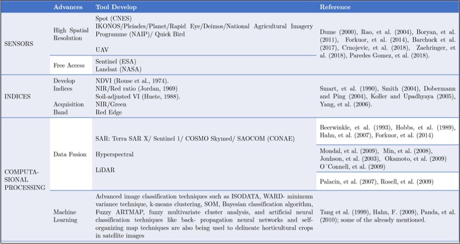
B. Challenges
The study of the remote sensing in horticultural activity is challenging to researchers given its particular characteristics. Context and fragmentation. Added to that, the size (Figure 4) and the diversity of crops (Figure 5) that make the orchards up, those interfere on the spectral reception of the sensor and make even more important that it have high spatial, spectral and radiometric resolution 52.
Figure 4.The scale and diversity of crops, of the fields in the area of urban- rural interface in the periurban of Co´rdoba. Reference 100m (image source: Photogrammetry, IGN, 2016)
Figure 5.Photography of diversity crops on orchard, cloudy day and tool for spectral measurements on horticulture.
The challenges facing by the horticultural RS technology can basically be summed up in three questions: Where?, What? and How much?. By WHERE we mean to try to map the area under horticultural cultivation in a certain region, for example the Green Belt of a big cities. Since the horticultural crop is basically a land use and not a land cover, it does not have a unique radiometric response, and then its classification is not a simple issue. Increasing the level of complexity we are interested in knowing, WHAT i.e., differentiate the type of horticultural crop. Basically it mean to know if it is lettuce, cabbage, beet, or others. These different species of vegetables can have different spectral signatures, but the spatial scale of each crop is too small for the multispectral or hyperspectral remote sensing and the necessary spatial resolution is until now not easily accessible. Finally and even more complex is to try to quantify the production of each crop. That is to say HOW MUCH or how many kg per square meter of a certain vegetable is available to be harvested.
Other characteristic important for GRS in horticulture are the difference in harvest dates, derived from the crops diversity and market strategies. The growth stages and phenology of many horticultural crops are not well understood and tend to be difficult to generalize as a result of wide variations in varieties, planting densities, and cultural practices 52. Despite that, the RS studies seems a useful tool for identifying optimal harvest dates 28.
However, the reliance of optical systems on the Sun’s energy limits image acquisition in cloudy or hazy conditions (Figure 5). Images acquired during these periods are normally of little use in mapping due to high cloud/haze cover.
Nevertheless synthetic aperture radar (SAR) systems are nearly independent of weather conditions. Unlike optical sensors, active radar systems have their own source of energy, transmitting radio waves and receiving the reflected echoes from objects on the Earth’s surface 58. Data fusion between SAR, optical high resolution systems and ancillary data is explore to overcome this problem 52, 32.
Another issue is the lack of field survey for horticulture planing and territorial management, the multi-date nature of satellite imagery permits monitoring dynamic features of landscape and thus provides a means to detect major land cover changes and quantify the rates of change 52. Prior knowledge and ancillary information obtained by RS and non-destructive soil and plant sensors can be used to design protocols that provide an appropriate balance between statistical precision and cost 59.
More advanced and accessible tools from a computational perspective open also more opportunities to use the new remote sensing data for operative applications on horticulture. In particular methodologies such as object based image analysis (OBIA), and machine and deep learning usually used in the field of the computer vision are closely related to the access to very high spatial resolution images (VHRI) (2cm of pixel size) for example from Drone. As an example, in the Figure 6 we present an image of a drone on a broccoli orchard. This image have spatial resolution of 2.5cm where each plant can be seen individually and so tools such us convolutionals neural networks used in computer vision, and easily accessible from, for example, python image processing libs, could be applied here for an exhaustive count of this crop.
Figure 6.RGB Drone image on a broccoli orchard. Own acquisition.
Conclusion
Although remote sensors are performed a lot of advantages to determine and study major crops, those studies have not included most horticultural crops 60.
It is striking how despite the importance of horticulture in aspects mentioned in this work such as food security, health, social and labor aspects, geospatial tools are used only marginally in their operational management.
In line with these two aspects mentioned above, scientific production in the area of RS applications in horticulture, as shown here, is still very limited and incipient.
However GRS in horticulture has a promising future account of sensors and platforms with higher resolutions, free-access collection imagery (i.e. Sentinel-ESA and Landsat-NASA), aircraft-mounted sensors, UAVs, the power of computational processing, fusion data, the mayor accesses to digital big data, and the historical yield information. Added to the context of human security with the approach of food needs and territorial management, brings a new perspective to analyze and study the horticulture.
So in this contribution we have presented to the reader a brief review on the experiences on the use of remote sensing in peri-urban production together with aspects related to the importance of this field and some interesting perspectives for future; thus trying to excite both the academic community and users about the use of geospatial technology in horticuture.
References
- 2.Altieri M, C I Nicholls. (2000) Teoría y práctica para una agricultura sustentable,” Serie Textos Bàsicos para la Formación Ambiental. 1.
- 4.D R Easterling, G A Meehl, Parmesan C, S A Changnon, T R Karl et al. (2000) Climate extremes: observations, modeling, and impacts,”science. 289(5487), 2068-2074.
- 5.A E Brown, Zhang L, T A McMahon, A W Western, R A Vertessy. (2005) A review of paired catchment studies for determining changes in water yield resulting from alterations in vegetation.Journal of hydrology.310(1-4). 28-61.
- 6.N W Arnell. (2004) Climate change and global water resources: Sres emissions and socio-economic scenarios,”Global environmental change. 14(1), 31-52.
- 7.A M Thomson, R A Brown, N J Rosenberg, Srinivasan R, R C Izaurralde. (2005) Climate change impacts for the conterminous usa: an integrated assessment,”Climatic change. 69(1), 67-88.
- 8.OMS. (2004) Estrategia mundial de regimen alimentario, actividad fisica y salud. ginebra. resolución,” OMS publication,WHA55.23
- 9.OPS “Plan.de acción para la prevención y el control de las enfermedades no transmisibles en las americas 2013-2029,”OPSpublication.
- 11.Giobellina B.Dinámicas territoriales del cinturón verde de Córdoba,” La alimentación de las ciudades. 21.
- 12.B L Giobellina. (2018) La alimentación de las ciudades. transformaciones territoriales y cambio climático en el cinturón verde de córdoba.,” tech. rep. , Ediciones INTA
- 13.Barsky A. (2005) El periurbano productivo, un espacio en constante transformación. Introducción al estado del debate, con referencias al caso de Buenos Aires,” Scripta Nova. 9(194), 36.
- 14.N A Mari, B L Giobellina, Benitez A, M V. (2019) Mapping and characterizing the green belt of Córdoba: Land dynamics and the urban-rural transformation process,”. , Journal of Agronomy and Research 2(1), 29-46.
- 15.A H Barchuk, L S Suez, Locati L. (2017) Cobertura y uso de la tierra en el área periurbana de la ciudad de. Aportes a la planificación territorial” Revista de la Asociación Argentina de Ecología de Paisajes , Córdoba, Argentina 7, 15-36.
- 16.Rosenzweig C, Hillel D. (2008) Climate variability and the global harvest: Impacts of El Niño and other oscillations on agro-ecosystems”.OxfordUniversityPress.
- 17.Serageldin I. (2002) Nurturing and nourishing the world’s poor: Important roles for horticulture in sustainable development,”. in XXVI International Horticultural Congress: Horticulture, Art and Science for Life-The Colloquia Presentations 642 25-34.
- 18.Assessment. (2005) Millennium Ecosystem and others Ecosystems and human well-being. , Washington, DC: 5.
- 19.Sarandón S J, Flores C C. (2014) Agroecología: bases teóricas para el diseño y manejo de agroecosistemas sustentables,” Colección libros de càtedra. Editorial de la Universidad Nacional de La Plata. Capítulo 5, 131-158.
- 21.C I Nicholls. (2008) Control biológico de insectos: un enfoque agroecológico. Universidad de. , Antioquia
- 22.Pérez M, Marasas M E. (2013) Servicios de regulación y prácticas de manejo: aportes para una horticultura de base agroecológica,” Revista Ecosistemas. 22(1), 36-43.
- 24.Batista D R Ponvert-Delisles. (2016) Algunas consideraciones sobre el comportamiento de la sequía agrícola en la agricultura de Cuba y el uso de imágenes por satélites en su evaluación,” Cultivos Tropicales. 37(3), 22-41.
- 25.Boryan C, Yang Z, Mueller R, Craig M. (2011) Monitoring us agriculture: the us department of agriculture, national agricultural statistics service, cropland data layer program,”. , Geocarto International 26(5), 341-358.
- 26.Crnojević V, Lugonja P, B N. (2014) Classification of small agricultural fields using combined landsat-8 and rapideye imagery: case study of northern serbia,”. , Journal of Applied Remote Sensing 8(1), 083512.
- 27.V P Gómez, Medina V D B, J L Bengoa, García D A N. (2018) Accuracy assessment of a 122 classes land cover map based on sentinel-. 2, landsat 8 and deimos-1 images and ancillary data,” in IGARSS 2018-2018 IEEE International Geoscience and Remote Sensing Symposium 5453-5456.
- 28.P N Rao, Ravishankar H, Raj U, Nagajothi K. (2004) Production estimation of horticultural crops using irs-1d liss-iii data,”. , Journal of the Indian Society of Remote Sensing 32(4), 393-398.
- 29.Okamoto H, Suzuki Y, Kataoka T, Sakai K. (2008) Unified hyperspectral imaging methodology for agricultural sensing using software framework,”. in International Symposium on Application of Precision Agriculture for Fruits and Vegetables 824: 49-56.
- 30.Panda S S, Hoogenboom G, Paz J O. (2010) Remote sensing and geospatial technological applications for site-specific management of fruit and nut crops: a review,” Remote Sensing. 2(8), 1973-1997.
- 31.N’Doume C, Lachenaud P, Hussard A, Nguyen H, Flori A. (1999) Etude de faisabilité pour l'élaboration d'une cartographie statistique d'inventaire des vergers café et cacao en Côte d'Ivoire par télédétection satellitale.
- 32.Forkuor G, Conrad C, Thiel M, Ullmann T, Zoungrana E. (2014) Integration of optical and synthetic aperture radar imagery for improving vol.WDC.USA,2013.crop mapping in northwestern benin, west Africa.”Remote sensing. 6(7), 6472-6499.
- 33.J G Zaehringer, Wambugu G, Kiteme B, Eckert S. (2018) How do largescale agricultural investments affect land use and the environment on the western slopes of mount kenya? empirical evidence based on small-scale farmers' perceptions and remote sensing,”. , Journal of environmental management 213, 79-89.
- 34.Smart R, J K Dick, I M Gravett, Fisher B. (1990) Canopy management to improve grape yield and wine quality-principles and practices,” South african journal of Enology and Viticulture. 11(1), 3-17.
- 35.Smith K, Steven M, Colls J. (2004) Use of hyperspectral derivative ratios in the red-edge region to identify plant stress responses to gas leaks,” Remote sensing of environment. 92(2), 207-217.
- 36.Dobermann A, Ping J. (2004) Geostatistical integration of yield monitor data and remote sensing improves yield maps,”. , Agronomy 96(1), 285-297.
- 37.Koller M, Upadhyaya S. (2005) Prediction of processing tomato yield using a crop growth model and remotely sensed aerial images,”. , Transactions of the ASAE 48(6), 2335-2341.
- 38.Beerwinkle K, Witz J, Schleider P. (1993) An automated, vertical looking, x-band radar system for continuously monitoring aerial insect activity,”. , Transactions of the ASAE 36(3), 965-970.
- 39.Hobbs S, Wolf W. (1989) An airborne radar technique for studying insect migration,”. , Bulletin of Entomological Research 79(4), 693-704.
- 40.Hahn F. (2007) Automatic detection of black pulp mango in a sorting system,” in. ASAE Annual Meeting, p. 1, American Society of Agricultural and Biological Engineers .
- 41.Mondal P, Basu M. (2009) Adoption of precision agriculture technologies in india and in some developing countries: Scope, present status and strategies,”. Progress in Natural Science 19(6), 659-666.
- 42.Min M, W S Lee, T F Burks, J D, A W Schumann et al. (2008) Design of a hyperspectral nitrogen sensing system for orange leaves,” Computers and electronics in agriculture. 63(2), 215-226.
- 43.Johnson L, Roczen D, Youkhana S, Nemani R, Bosch D. (2003) Mapping vineyard leaf area with multispectral satellite imagery,” Computers and electronics in agriculture. 38(1), 33-44.
- 44.O’Connell M, Whitfield D, Abuzar M, Sheffield K, McClymont L et al. (2010) Satellite remote sensing of crop water use in perennial horticultural crops,”. in Program and abstracts Australian irrigation conference held in Sydney in 129-130.
- 45.Palacín J, Palleja` T, Tresanchez M, Sanz R, Llorens J et al. (2007) Real-time tree-foliage surface estimation using a ground laser scanner,”. , IEEE Transactions on Instrumentation and Measurement 5(4), 1377-1383.
- 46.J R Rosell, Llorens J, Sanz R, Arno J, Ribes-Dasi M et al. (2009) Obtaining the three-dimensional structure of tree orchards from remote 2d terrestrial lidar scanning,” Agricultural and Forest Meteorology. 149(9), 1505-1515.
- 47.Tang L, Tian L, Steward B, Reid J. (1999) Texture-based weed classification using gabor wavelets and neural network for real-time selective herbicide applications,”. , Urbana 51, 61801.
- 48.Hahn F. (2009) Actual pathogen detection: sensors and algorithms-a review,”. , Algorithms 2(1), 301-338.
- 49.J Rouse, Haas R, Schell J, Deering D. (1974) Monitoring vegetation systems in the great plains with erts,”.
- 50.A R Huete. (1988) A soil-adjusted vegetation index (savi),” Remote sensing of environment. 25(3), 295-309.
- 51.C F Jordan. (1969) Derivation of leaf-area index from quality of light on the forest floor,”. , Ecology 50(4), 663-666.
- 52.Usha K, Singh B. (2013) Potential applications of remote sensing in horticulture—a review,”. , Scientia Horticulturae 153, 71-83.
- 53.Parsons N, Edmondson R, Song Y. (2009) Image analysis and statistical modelling for measurement and quality assessment of ornamental horticulture crops in glasshouses,”. , Biosystems engineering 104(2), 161-168.
- 54.Alvino A, Marino S. (2017) Remote Sensing for Irrigation of Horticultural Crops,” Horticulturae. 3(2), 40.
- 55.Mahlein A-K, Oerke E-C, Steiner U, Dehne H-W. (2012) Recent advances in sensing plant diseases for precision crop protection,”. , European Journal of Plant Pathology 133, 197-209.
- 56.Nilsson H. (1995) Remote sensing and image analysis in plant pathology,” Annual review of phytopathology. 33(1), 489-528.
- 57.H K Lichtenthaler. University of Nottingham (1989) Applications of chlorophyll fluorescence in stress physiology and remote sensing, Applications of remote sensing in agriculture. Proceedings of the 48th Easter School in Agricultural Science 287-305.
- 58.Jensen J R. (2009) Remote sensing of the environment: An earth resource perspective 2/e. Pearson Education India.
Cited by (8)
- 1.Padmavathi M, Manikandan M., Sumithra M. G., Dhivyasri G., Inbanathan Flavia P. N., 2024, , , 1170(), 109, 10.1007/978-3-031-67450-1_5
- 2.Sarabandi Melina, Zargar Meisam, Ghorbani Abazar, Chen Moxian, 2025, Smart and sustainable nano-biosensing technologies for advancing stress detection and management in agriculture and beyond, Industrial Crops and Products, 226(), 120713, 10.1016/j.indcrop.2025.120713
- 3.Mahto Manoj Kumar, Srivastava Santosh Kumar, Sah Basant, 2024, , , (), 1, 10.1002/9781394302994.ch1
- 4.Bharti Anjali, Jain Utkarsh, Chauhan Nidhi, 2024, From lab to field: Nano-biosensors for real-time plant nutrient tracking, Plant Nano Biology, 9(), 100079, 10.1016/j.plana.2024.100079
- 6.Dhanaraju Muthumanickam, Chenniappan Poongodi, Ramalingam Kumaraperumal, Pazhanivelan Sellaperumal, Kaliaperumal Ragunath, 2022, Smart Farming: Internet of Things (IoT)-Based Sustainable Agriculture, Agriculture, 12(10), 1745, 10.3390/agriculture12101745
- 7.Khursheed Vajahat , Taufique Mohammad , 2021, Land Use Land Cover Change Detection and Measuring Horticulture Expansion through Remote Sensing and GIS Techniques in Rambiara Catchment, Kashmir Valley, India, Creative Space, 8(2), 49, 10.15415/cs.2021.82004